
My final major project has always contained a journey narrative the working title Tilbury to Harwich expresses that aspect of the project. During my initial research for the project in the positions and practices module in my research proposal research-project-proposal-assignment I referenced the performance related work of artists such as Richard Long and Hamish Fulton. I wanted to introduce influences from these artists into my own project. Ken Worpole in 2005 published a book ‘350 miles An Essex Journey’ (Orton and Worpole, 2005) using that as a reference I thought it would be useful to position the photographs against the distance covered between Tilbury and Harwich with the images representing milestone markers.
Given my challenge of fitting this project around my job in London I decided that creating a virtual walk along the high water line along the coast would allow me to introduce this performance element into the project’s narrative.The 1960s and early 1970s my father and uncle entered rally events in a mini, as navigator it was my fathers job to plot the route on the maps ahead of the events so that he could read out directions and allow then to get the the stages on time and drive them as fast as possible. Therefore I remember my father sat in the living room with local Ordnance Survey maps plotting the route.
I decided that I would use the same approach to plot my theoretical route from Tilbury to Harwich along the coastline. The Ordnance Survey maps show the mean High Water and Low Water levels on the maps for my journey I decided I would follow the High Water Mark that represents the edge smallest version of the land that is Essex. Trying to travel following the low water mark along the Essex coast would be problematic due to the mudflats that make up parts of the Thames Estuary and the Blackwater Estuary.
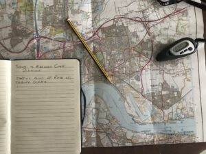
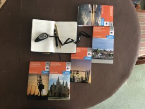
To measure the coastline I purchased copies of the 5 Ordnance Survey maps that covered the Essex coast and purchased a digital measuring device rather than using a piece of string a ruler which is how I might have done it as a child. The reason for this approach was I wanted to achieve a level of precision measuring distance along the high water level of the coast.
Tracking the coast was going to be a large undertaking as requiring care a precision. I started to slowly measure the coastline in short sections to minimise errors and measured the distance 3 times and averaged the result to get my distance. This was going to be a significant undertaking that I think will take many hours over the next couple of months to complete.
Reference
- Orton, J. and Worpole, K. (2005). 350 miles. [S.l.: s.n.].